Trail Walking District of Poprad - randonnée Tatras slovaque  - Photo
© OpenStreetMap contributors
Length
Length
16.3 km
Max alt
Max alt
1553 m
Uphill gradient
Uphill gradient
389 m
Km-Effort
Km-Effort  
22 km
Min alt
Min alt
1220 m
Downhill gradient
Downhill gradient
486 m
Boucle
Boucle
No
Creation date :
2023-07-21 09:32:22.126
Updated on :
2023-08-13 04:39:18.634

(0 Reviews)

Walking
Walking
7h40
Difficulty : Medium

Scan this QR Code to open this trail in the SityTrail application

FREE GPS app for hiking

Logo SityTrail SityTrail

IGN / Geographical institutes

Download SityTrail from the App Store Download SityTrail from Google Play

Logo SityTrail SityTrail World

The world is yours!

Download SityTrail from the App Store Download SityTrail from Google Play Download SityTrail on Huawei AppGallery

About

Trail Walking of 16.3 km to be discovered at Region of Prešov, Unknown, District of Poprad. This trail is proposed by bene_dictus77.

Description

randonnée montagnes du 21/07/2023

Elevation profile

Positioning

Country:
Slovakia
Region :
Region of Prešov
Department/Province :
Unknown
Municipality :
District of Poprad
Location:
Štrba
Start:(UTM)
431638 ; 5440997 (34U) N.

Trails nearby

Trail Walking District of Poprad - Strbské Pleso - Furkotsky Stit - Photo
Walking
sit68000

Walking

Very difficult
District of Poprad, Region of Prešov, Unknown, Slovakia
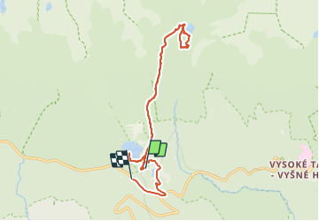
13.1 km | 28 km-effort
6h 22min
Yes


Close
My subscriptions